
Kanoya, Kagoshima
Kanoya
鹿屋市 | |
|---|---|
 Top left: Kanoya Rose Park, Top right: Kushira Memorial Tower, 2nd left: Kanoya Ring City, 2nd middle: Kanoya University of Physical Education, 2nd right: Mount Aira Tomb, 3rd left: Kasanohara Plateau, 3rd middle: Kihoku Celestial Sphere Museum, Bottom left :Kimotsuki River and Mount Takakuma, Bottom right: Kanoya Summer Festival | |
 Flag  Emblem | |
 Location of Kanoya in Kagoshima Prefecture | |
 Kanoya Location in Japan | |
| Coordinates: 31°22′42″N 130°51′8″E / 31.37833°N 130.85222°E | |
| Country | Japan |
| Region | Kyushu |
| Prefecture | Kagoshima |
| Government | |
| • Mayor | Shigeru Nakanishi |
| Area | |
| • Total | 448.15 km2 (173.03 sq mi) |
| Population (March 1, 2024) | |
| • Total | 98,367 |
| • Density | 220/km2 (570/sq mi) |
| Time zone | UTC+09:00 (JST) |
| City hall address | 20-1 Kyōeichō, Kanoya-shi, Kagoshima-ken 893-8501 |
| Climate | Cfa |
| Website | Official website |
| Symbols | |
| Flower | Rose |
| Tree | Camphor laurel |

Kanoya (鹿屋市, Kanoya-shi) is a city in Kagoshima Prefecture, Japan. As of 1 March 2024[update], the city had an estimated population of 98,367 in 46114 households, and a population density of 100 persons per km².[1] The total area of the city is 448.15 km2 (173.03 sq mi). Kanoya is also popularly called the "Town of Roses".[2]
Geography[edit]
Kanoya is located approximately at the heart of Ōsumi Peninsula with its city limits running approximately 20 kilometres (12 mi) east and west and 41 kilometres (25 mi) north and south. The Takakuma Mountains stretch out into the northwestern part of the city and the Kimotsuki Mountains in the southeast. Between both mountain ranges lie the Kasanohara and Kanoyahara plateaus. The Kimotsuki Plains spread through the alluvial plains of the Kimotsuki River that runs through central Kanoya. In the western part of the city is Kinkō Bay (part of Kagoshima Bay) which runs down the coast line.
Neighboring municipalities[edit]
Kagoshima Prefecture
-
 View of downtown Kanoya from Kanoya City Hall
 -
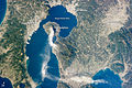 An image taken from the International Space Station showing Kanoya and its surroundings on January 10, 2013


Climate[edit]
Kanoya has a humid subtropical climate (Köppen climate classification Cfa) with hot summers and mild winters. Precipitation is significant throughout the year, and is heavier in summer, especially the months of June and July. The average annual temperature in Kanoya is 17.3 °C (63.1 °F).[3] The average annual rainfall is 2,685.6 mm (105.73 in) with June as the wettest month. The temperatures are highest on average in August, at around 27.5 °C (81.5 °F), and lowest in January, at around 7.5 °C (45.5 °F).[4] Its record high is 37.6 °C (99.7 °F), reached on 18 August 2020, and its record low is −8.0 °C (17.6 °F), reached on 25 January 2016.[5]
| Climate data for Kanoya (1991−2020 normals, extremes 1977−present) | |||||||||||||
|---|---|---|---|---|---|---|---|---|---|---|---|---|---|
| Month | Jan | Feb | Mar | Apr | May | Jun | Jul | Aug | Sep | Oct | Nov | Dec | Year |
| Record high °C (°F) | 22.7 (72.9) |
23.6 (74.5) |
25.9 (78.6) |
29.6 (85.3) |
33.0 (91.4) |
34.2 (93.6) |
35.8 (96.4) |
37.6 (99.7) |
35.8 (96.4) |
33.0 (91.4) |
28.5 (83.3) |
24.6 (76.3) |
37.6 (99.7) |
| Mean daily maximum °C (°F) | 12.8 (55.0) |
14.2 (57.6) |
17.0 (62.6) |
21.3 (70.3) |
25.1 (77.2) |
26.9 (80.4) |
31.3 (88.3) |
32.1 (89.8) |
29.7 (85.5) |
25.4 (77.7) |
20.2 (68.4) |
15.0 (59.0) |
22.6 (72.7) |
| Daily mean °C (°F) | 7.5 (45.5) |
8.8 (47.8) |
11.8 (53.2) |
16.0 (60.8) |
20.0 (68.0) |
23.0 (73.4) |
27.0 (80.6) |
27.5 (81.5) |
24.9 (76.8) |
20.0 (68.0) |
14.5 (58.1) |
9.4 (48.9) |
17.5 (63.6) |
| Mean daily minimum °C (°F) | 1.9 (35.4) |
3.0 (37.4) |
6.3 (43.3) |
10.4 (50.7) |
15.1 (59.2) |
19.7 (67.5) |
23.6 (74.5) |
23.9 (75.0) |
21.0 (69.8) |
15.1 (59.2) |
8.9 (48.0) |
3.5 (38.3) |
12.7 (54.9) |
| Record low °C (°F) | −8.0 (17.6) |
−6.8 (19.8) |
−4.4 (24.1) |
−1.0 (30.2) |
3.7 (38.7) |
9.1 (48.4) |
15.5 (59.9) |
17.0 (62.6) |
9.3 (48.7) |
1.2 (34.2) |
−3.5 (25.7) |
−6.6 (20.1) |
−8.0 (17.6) |
| Average precipitation mm (inches) | 80.3 (3.16) |
119.2 (4.69) |
173.2 (6.82) |
196.9 (7.75) |
219.8 (8.65) |
623.0 (24.53) |
425.6 (16.76) |
282.9 (11.14) |
288.2 (11.35) |
138.3 (5.44) |
100.6 (3.96) |
77.5 (3.05) |
2,685.6 (105.73) |
| Average precipitation days (≥ 1.0 mm) | 8.7 | 9.3 | 12.8 | 11.1 | 10.6 | 17.2 | 12.3 | 12.5 | 11.3 | 7.9 | 8.6 | 7.2 | 129.5 |
| Mean monthly sunshine hours | 151.5 | 152.1 | 167.5 | 176.6 | 173.2 | 99.6 | 183.7 | 202.0 | 161.1 | 176.9 | 157.6 | 156.6 | 1,961.7 |
| Source: Japan Meteorological Agency[5][4] | |||||||||||||
| Climate data for Kihoku, Kanoya (1991−2020 normals, extremes 1977−present) | |||||||||||||
|---|---|---|---|---|---|---|---|---|---|---|---|---|---|
| Month | Jan | Feb | Mar | Apr | May | Jun | Jul | Aug | Sep | Oct | Nov | Dec | Year |
| Record high °C (°F) | 20.7 (69.3) |
21.2 (70.2) |
24.2 (75.6) |
27.9 (82.2) |
31.4 (88.5) |
36.0 (96.8) |
34.7 (94.5) |
36.4 (97.5) |
33.9 (93.0) |
30.9 (87.6) |
29.4 (84.9) |
21.5 (70.7) |
36.4 (97.5) |
| Mean daily maximum °C (°F) | 9.9 (49.8) |
11.4 (52.5) |
14.6 (58.3) |
19.3 (66.7) |
23.3 (73.9) |
25.2 (77.4) |
29.4 (84.9) |
30.1 (86.2) |
27.5 (81.5) |
22.9 (73.2) |
17.5 (63.5) |
12.1 (53.8) |
20.3 (68.5) |
| Daily mean °C (°F) | 5.8 (42.4) |
6.9 (44.4) |
9.8 (49.6) |
14.2 (57.6) |
18.3 (64.9) |
21.3 (70.3) |
25.2 (77.4) |
25.5 (77.9) |
22.8 (73.0) |
18.1 (64.6) |
12.9 (55.2) |
7.9 (46.2) |
15.7 (60.3) |
| Mean daily minimum °C (°F) | 1.9 (35.4) |
2.6 (36.7) |
5.4 (41.7) |
9.6 (49.3) |
14.1 (57.4) |
18.2 (64.8) |
22.1 (71.8) |
22.3 (72.1) |
19.4 (66.9) |
14.2 (57.6) |
8.7 (47.7) |
3.7 (38.7) |
11.8 (53.3) |
| Record low °C (°F) | −8.3 (17.1) |
−7.1 (19.2) |
−3.1 (26.4) |
0.2 (32.4) |
3.3 (37.9) |
11.3 (52.3) |
14.2 (57.6) |
16.4 (61.5) |
10.1 (50.2) |
3.4 (38.1) |
−2.1 (28.2) |
−5.2 (22.6) |
−8.3 (17.1) |
| Average precipitation mm (inches) | 87.1 (3.43) |
131.9 (5.19) |
192.3 (7.57) |
230.9 (9.09) |
258.2 (10.17) |
676.2 (26.62) |
460.5 (18.13) |
298.0 (11.73) |
325.7 (12.82) |
136.1 (5.36) |
112.5 (4.43) |
92.6 (3.65) |
3,001.9 (118.19) |
| Average precipitation days (≥ 1.0 mm) | 8.9 | 9.5 | 13.1 | 11.5 | 11.4 | 17.5 | 13.7 | 13.5 | 12.4 | 8.3 | 8.7 | 8.2 | 136.7 |
| Mean monthly sunshine hours | 141.8 | 141.9 | 163.9 | 167.2 | 166.3 | 86.1 | 149.8 | 164.3 | 138.7 | 168.1 | 151.4 | 145.2 | 1,795.6 |
| Source: Japan Meteorological Agency[6][7] | |||||||||||||
Demographics[edit]
Within Kagoshima Prefecture, Kanoya is the third most populous city next to Kagoshima (the prefectural capital) and Kirishima.
|
| |||||||||||||||||||||||||||||||||||||||||||||||||||||||||||||||||||||
| Kanoya population statistics[8] | ||||||||||||||||||||||||||||||||||||||||||||||||||||||||||||||||||||||
History[edit]
The area of Kanoya was part of ancient Ōsumi Province, and was part of the Shimazu-shō, a vast shōen landed manor in Ōsumi, Satsuma that was opened at the end of the Heian period, and which evolved into Satsuma Domain in the Edo period . After the Meiji restoration, the village of Kanoya was established with the creation of the modern municipalities system on April 1, 1889. Kanoya was raised to town status on December 31, 1912. On May 27, 1941 Kanoya merged with the villages of Hanaoka and Oaira to form the city of Kanoya.
In 2006, the original city of Kanoya was expanded following the merger of the two towns of Aira and Kushira in Kimotsuki District, and Kihoku in Soo District.[9] The original Kanoya City was established as a municipality on May 27, 1941 (Navy Memorial Day).[citation needed]
Government[edit]
Kanoya has a mayor-council form of government with a directly elected mayor and a unicameral city council of 26 members. Kanoya, collectively with the city of Tarumizu contributes four members to the Kagoshima Prefectural Assembly. In terms of national politics, the city is part of the Kagoshima 4th district of the lower house of the Diet of Japan.
Kanoya is home to the Japan Maritime Self-Defense Force Kanoya Air Field.
Economy[edit]
Kanoya has a primary economy centering on agriculture, fishing, livestock raising and food processing. Kanoya's specialties include Berkshire pig, peanuts, broilers, and sweet potatoes.
Education[edit]
Kanoya has 23 public elementary schools and 12 public junior high schools operated by the city government and five public high schools operated by the Kagoshima Prefectural Board of Education. There is also one private high school. The city also hosts the National Institute of Fitness and Sports in Kanoya.
Transportation[edit]
Railway[edit]
Kanoya is the most populous city in Japan outside of Okinawa Prefecture without passenger rail services, after the closure of the Ōsumi Line in 1987.[10]
The nearest station is Shibushi Station on the JR Kyushu Nichinan Line, but the nearest practical station is Kagoshima-Chūō Station on the Kyushu Shinkansen. In both cases, it takes more than an hour to reach the station by private car, or two hours by bus.
Highway[edit]
Local attractions[edit]
Notable people from Kanoya[edit]
- Sunshine Ikezaki (Real Name: Satoru Ikezaki, Nihongo: 池崎 慧, Ikezaki Satoru), Japanese comedian
- Yuka Nishida (Nihongo: 西田 優香, Nishida Yuka), Japanese judoka
- Sayuri Kokushō (Nihongo: 国生さゆり or 國生さゆり, Kokusho Sayuri), Japanese actress, singer, and tarento
- Taiga Satoru (Real Name: Satoshi Kawasaki, Nihongo: 川崎悟司, Kawasaki Satoshi), Japanese sumo wrestler
- Yamato Maeda (Nihongo: 前田 大和, Maeda Yamato), Japanese professional baseball outfielder (Yokohama DeNA BayStars, Nippon Professional Baseball)
- Sakura Yokomine (Nihongo: 横峯さくら, Yokomine Sakura), Japanese professional golfer (LPGA Tour and LPGA of Japan Tour)
References[edit]
- ^ "Kanoya City official statistics" (in Japanese). Japan.
- ^ "鹿屋市(かのや市)|ばらのまち かのや ポータルページ". E-kanoya.net. Retrieved 2015-11-20.
- ^ "鹿児島県 鹿屋の気温、降水量、観測所情報". Weather.time-j.net. Retrieved 2015-11-20.
- ^ a b 気象庁 / 平年値(年・月ごとの値). JMA. Retrieved March 26, 2022.
- ^ a b 観測史上1~10位の値(年間を通じての値). JMA. Retrieved March 26, 2022.
- ^ 観測史上1~10位の値(年間を通じての値). JMA. Retrieved March 26, 2022.
- ^ 気象庁 / 平年値(年・月ごとの値). JMA. Retrieved March 26, 2022.
- ^ Kanoya population statistics
- ^ Kanoya Merger
- ^ "鉄道のない市 人口ベスト10". Archived from the original on 2018-10-10. Retrieved 2018-08-08.
External links[edit]
- Official website
 (in Japanese)
 - Kanoya International Exchange Association (in English)
 Geographic data related to Kanoya, Kagoshima at OpenStreetMap
| Core city | |||||||||||
|---|---|---|---|---|---|---|---|---|---|---|---|
| Cities |
| ||||||||||
| Districts |
| ||||||||||
| International | |
|---|---|
| National | |
| Geographic | |
| Academics | |
| Other | |