
Torcy station
Torcy | |||||||||||
|---|---|---|---|---|---|---|---|---|---|---|---|
 Main entrance at south side (towards the bus station and Bay 2 shopping centre). | |||||||||||
| General information | |||||||||||
| Location | 1 Place de la Gare Torcy France | ||||||||||
| Coordinates | 48°50′22″N 2°39′17″E / 48.8394°N 2.6547°E | ||||||||||
| Operated by | RATP Group | ||||||||||
| Platforms | 1 island platform 1 side platform | ||||||||||
| Tracks | 3 | ||||||||||
| Construction | |||||||||||
| Structure type | Below-grade | ||||||||||
| Parking | Yes | ||||||||||
| Accessible | Yes, by request to staff[1] | ||||||||||
| Other information | |||||||||||
| Station code | 87758375 | ||||||||||
| Fare zone | 5 | ||||||||||
| History | |||||||||||
| Opened | 19 December 1980 | ||||||||||
| Passengers | |||||||||||
| 2019 | 4,223,220 | ||||||||||
| Services | |||||||||||
| |||||||||||
Torcy station (French pronunciation: [toʁsi]) is a railway station in Torcy, Seine-et-Marne, a suburb east of Paris.
History[edit]
Torcy opened on 19 December 1980 as part of an extension of the A4 branch from its previous eastern terminal of Noisy-le-Grand–Mont d'Est. It served as the eastern terminus of the A4 branch for twelve years until 1 April 1992, when the RER A4 was extended to Marne-la-Vallée–Chessy; since then, the A4 branch has yet to be extended.
Traffic[edit]
As of 2019[update], the estimated annual attendance by the RATP Group was 4,223,220 passengers.[2]
Service[edit]
Torcy is on the A4 branch of the RER A and receives frequent service. As of 4 February 2008, during peak hours there are between twelve and eighteen trains per hour (intervals of five and three minutes and twenty seconds), during mid-day trains arrive every ten minutes, and early mornings and late nights trains come at fifteen-minute intervals.[3][4]
The station acts as a terminus for certain trains. Trains that terminate at Torcy will display a headline beginning with O, O being the designation that a train terminates at Torcy rather than Q for Marne-la-Vallée–Chessy.[4]
Bus connections[edit]
The station is served by several buses:
 RATP Bus network lines: 211, 220, 321 and 421 ;[5][6]
- Pep's Bus network lines: 13, 21, 25, 29 and 46 ;[5][6]
- Seine-et-Marne Express Bus network lines: 18 and 19 ;[5][6]
- Stigo Bus network line: 18 ;[5][6]
- Transdev Lys (by Setra) Bus network line: 100 ;[5][6]
 Noctilien network night bus lines: N34 and N130.[6][7]
Gallery[edit]
-
 North side entrance
(towards Bay 1 shopping centre) -
 Sign indicating the name of the station
(with overlooking the neighbourhood) -
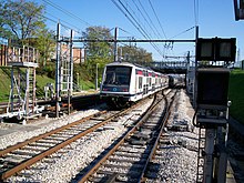
 A train (MI2N) arriving at the station
(towards Paris) -
 General view to the west (towards Paris)
from the east side of the station -
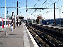 General view of the platforms to the east
(towards Marne-la-Vallée–Chessy) -
 General view to the east (with a MI2N train
that has just left the station)


References[edit]
- ^ "Plan pour les voyageurs en fauteuil roulant" [Map for travelers in wheelchairs] (PDF). Île-de-France Mobilités. 2023. Retrieved 27 December 2023.
- ^ "Trafic annuel entrant par station du réseau ferré 2019". Open Data RATP (Data.Ratp.fr) (in French). RATP Group. Retrieved 8 August 2021.
- ^ RER A timetable towards Cergy-le-Haut RATP Retrieved 24 December 2008
- ^ a b RER A timetable towards Marne-la-Vallée–Chessy RATP Retrieved 24 December 2008
- ^ a b c d e "Plan du réseau de bus à Marne-la-Vallée (Secteur n°11)" [Map of the RATP bus network in Marne-la-Vallée (Sector n° 11).] (PDF). Ratp.fr (Color map showing the names of bus stops and main streets.) (in French). RATP Group. May 2020. Retrieved 19 August 2020.
- ^ a b c d e f "Plan du réseau de bus à Marne-la-Vallée (Secteur n°45)" [Map of the bus networks in Marne-la-Vallée (Sector n° 45).] (PDF). Transdev-idf.com (Color map showing the names of bus stops and main streets.) (in French). Île-de-France Mobilités. January 2020. Retrieved 23 August 2020.
- ^ "Plan du réseau Noctilien (2017) – (Secteur : Paris & Sud-Est)" [Map of the night bus (Noctilien) network (2017) – (Sector: Paris and its south-eastern suburbs).] (PDF). Ratp.fr (Color map showing the names of the bus stops and the cities served.) (in French). RATP Group. April 2017. Retrieved 19 August 2020.
External links[edit]
![]() Media related to Gare de Torcy at Wikimedia Commons
Media related to Gare de Torcy at Wikimedia Commons