Fertile, Saskatchewan
Fertile | |
|---|---|
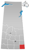
Location of Fertile in Saskatchewan | |
| Coordinates: 49°23′0″N 101°27′02″W / 49.38333°N 101.45056°W | |
| Country | |
| Province | |
| Region | Central Plains |
| Census Division | No. 1 |
| Government | |
| • Governing Body | Rural Municipality of Storthoaks Council |
| • MP | Ed Komarnicki |
| • MLA | Dan D'Autremont |
| Time zone | UTC−6 (CST) |
| Postal Code | S0C 0W0 |
| Area code(s) | 306, 639 |
Fertile is an unincorporated community in southeastern Saskatchewan, Canada, located 3 miles (4.8 km) west of the Manitoba border and 40 miles (64 km) north of the U.S. border in the Rural Municipality of Storthoaks No. 31.
Demographics[edit]
The population was once as high as 50 people, but now is supported by surrounding farm families. Fertile once had its own school (shrined), grain elevators (2), general store, skating/curling rink, United church, community hall and post office. Only the latter two survive. Families making up the current community include; Pickard(2), Holden(2), Malin (3), Rekken, Poirier, Millions, Bouchard (2), VanderWaal, Poirier. Fall suppers and an annual event, be it a comedy act, a magician, etc., used to be held to raise money to support the community hall.
Climate[edit]
| Climate data for Fertile | |||||||||||||
|---|---|---|---|---|---|---|---|---|---|---|---|---|---|
| Month | Jan | Feb | Mar | Apr | May | Jun | Jul | Aug | Sep | Oct | Nov | Dec | Year |
| Record high °C (°F) | 8.0 (46.4) |
17.5 (63.5) |
18.5 (65.3) |
33.9 (93.0) |
37.2 (99.0) |
38.3 (100.9) |
38 (100) |
39 (102) |
36.7 (98.1) |
33 (91) |
22.5 (72.5) |
11.7 (53.1) |
39 (102) |
| Mean daily maximum °C (°F) | −9.2 (15.4) |
−6.9 (19.6) |
0.2 (32.4) |
11.2 (52.2) |
18.4 (65.1) |
22.7 (72.9) |
25.7 (78.3) |
25.6 (78.1) |
19.1 (66.4) |
11.2 (52.2) |
−0.5 (31.1) |
−7.9 (17.8) |
9.1 (48.4) |
| Daily mean °C (°F) | −14.4 (6.1) |
−12 (10) |
−4.6 (23.7) |
4.7 (40.5) |
11.6 (52.9) |
16.3 (61.3) |
19.0 (66.2) |
18.3 (64.9) |
12.2 (54.0) |
4.9 (40.8) |
−5.2 (22.6) |
−12.7 (9.1) |
3.2 (37.8) |
| Mean daily minimum °C (°F) | −19.5 (−3.1) |
−17.1 (1.2) |
−9.4 (15.1) |
−1.9 (28.6) |
4.7 (40.5) |
9.9 (49.8) |
12.3 (54.1) |
10.9 (51.6) |
5.2 (41.4) |
−1.3 (29.7) |
−9.8 (14.4) |
−17.5 (0.5) |
−2.8 (27.0) |
| Record low °C (°F) | −40 (−40) |
−41 (−42) |
−38.3 (−36.9) |
−24.4 (−11.9) |
−10 (14) |
−1 (30) |
1.5 (34.7) |
−3 (27) |
−8.9 (16.0) |
−21 (−6) |
−32.5 (−26.5) |
−41.5 (−42.7) |
−41.5 (−42.7) |
| Average precipitation mm (inches) | 25.7 (1.01) |
18.5 (0.73) |
24.1 (0.95) |
31.0 (1.22) |
66.9 (2.63) |
82.4 (3.24) |
64.5 (2.54) |
50.4 (1.98) |
41.5 (1.63) |
35.7 (1.41) |
24.8 (0.98) |
24.7 (0.97) |
490.0 (19.29) |
| Source: Environment Canada[1] | |||||||||||||
See also[edit]
References[edit]
- ^ Environment Canada [1], accessed 13 August 2017


