User:Zoney
Fáilte - Welcome
My main interests are topics relating to Ireland, Rail transport or Road transport. | |||||
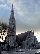
| image from Limerick: | for full article, see National Monument (Ireland):
 A National Monument in the Republic of Ireland, is a monument (or remains of) under preservation by the State, as a result of its being considered to be of national importance. As of 2006 the legal basis for this status are the National Monuments Acts 1930 to 2004 [1]. The original national monuments act by the current Irish state was enacted in 1930 as the National Monuments Act, 1930 [2]. The original itinerary of monuments comprises those to which the Ancient Monuments Protection Act, 1882 applied. | ||||
Articles of interest
These are some topics I am interested in, created, or significantly contributed to at some stage. While some items are listed here to show off my work, mostly this is just for my own reference, and to give others a flavour as to what I like doing on Wikipedia. (It's a bit more filtered and helpful than "User Contributions" special page.)
Europe
The European Union. See Infobox, Legal history and governing treaties and map.
Ireland (transport)
Two major elements to Transport in Ireland are the road network and rail network. Both are currently undergoing expansion and upgrade under the National Development Plan. The National Roads Authority is responsible for major roads in Ireland, which mainly focus around Dublin. The M50 circles the east of the city, with the M1 (N1), N2, N3, N4, N5, N6, N7, N8, N11 leading to other parts of the country.
Railways in Ireland have a long history. Iarnród Éireann now operates services in the Republic (except for Dublin's Luas tram system), with most lines running to/from Connolly, Pearse and Heuston Station in Dublin. A new terminal is planned for Spencer Dock. Many routes were built or operated by the Great Southern & Western Railway. Many lines were shut down over the years, such as the West Clare Railway. The Western Railway Corridor is a partly intact closed line, for which there is a campaign to be reopened. One of the Irish rail network's most well-known locations is Limerick Junction (track diagram). Rolling stock used on Irish railways includes British Rail Mark 2 and British Rail Mark 3.
Heritage railways in Northern Ireland include the Downpatrick Railway Museum and The Giants Causeway & Bushmills Railway.
Ireland (places)
The geography of Ireland reflects its situation as an island in northwest Europe in the north Atlantic Ocean. A ring of mountains surround low central plains, although some such as the Galtee Mountains are further inland. Peninsulas such as the Ards peninsula and Iveragh peninsula are common, with many islands (e.g. Achill Island, Fota Island, Great Island, Rathlin Island) also. Almost all cities in Ireland are on rivers, such as Cork on the River Lee. Major lakes such as Lough Erne, and minor ones such as Lough Gur are scattered through the country.
Most of Ireland's towns are settlements hundreds of years old. Letterkenny is one of the few major towns in the northwest of the Republic. South near the border are Longford Town and Roosky. Along the northwest coast are Ballina and Westport. Castlebar is located inland between the two. Further south on the west coast are Doolin and Kilkee, with Shannon Town (and Shannon Airport) located further inland towards Limerick. Hunt Museum and St. John's Cathedral are both in the city. Patrickswell is a town nearby. Cratloe, Bunratty Castle and Ennis are north of the city. Out towards the southwest coast from Limerick are Foynes and Listowel. South of Listowel is Farranfore, with Cahersiveen located further southwest out on the coast. Bantry is south again on the Western edge of West Cork. The city of Cork is located on the south coast. Further along is Dungarvan. Portmarnock is on the east coast near the capital. St. Stephen's Green is in the city centre. Mulhuddart is a town on the western outskirts and Stillorgan is a suburb south of the city. Alongside or along the route from Dublin to Limerick are Sallins and Naas, Droichead Nua (Newbridge) and Borris-in-ossory, with Portarlington located on the railway route. Clara and Moate are north of Portarlington, in the Midlands. Ballinakill, Durrow and Rathdowney are south of the Midlands, alongside the N8 route to Cork.
Ireland has provencial flags, with one each for Ulster, Munster, Connacht and Leinster.
Armagh Observatory is an attraction in Northern Ireland.
Ireland (maps)
- Physical map: Small, Medium, Large
- Towns in Westmeath
- Carlow-Kilkenny constituency
- Dublin admin divisions: Fingal, South Dublin, Dun Laoghaire-Rathdown, Dublin City
Template:NI district, added to each NI council article.
Ireland (topics)
- List of Ireland-related topics
- Bord na Móna, Charles Bianconi, Irish breakfast
- Architecture of Ireland
- Irish Rebellion of 1798
- Northern Bank robbery
Transport
- Grade separation
- Rail terminology
- Hope to start road terminology or motoring terminology
Other
 | This user is an Irish Wikipedian. There are things particularly relevant to Irish Wikipedians at the Irish Wikipedians' notice board. Please feel free to help us improve Ireland-related articles in Wikipedia! |

