
New Holland, Pennsylvania
New Holland, Pennsylvania | |
|---|---|
 House on West Main Street | |
| Etymology: Holland | |
 Location in Lancaster County, Pennsylvania | |
 New Holland Location in Pennsylvania  New Holland Location in the United States | |
| Coordinates: 40°06′08″N 76°05′16″W / 40.10222°N 76.08778°W | |
| Country | United States |
| State | Pennsylvania |
| County | Lancaster |
| Government | |
| • Mayor | Tim Bender |
| Area | |
| • Total | 1.94 sq mi (5.03 km2) |
| • Land | 1.94 sq mi (5.03 km2) |
| • Water | 0.00 sq mi (0.00 km2) |
| Elevation | 495 ft (151 m) |
| Population | |
| • Total | 5,743 |
| • Density | 2,955.74/sq mi (1,141.16/km2) |
| Time zone | UTC-5 (EST) |
| • Summer (DST) | UTC-4 (EDT) |
| ZIP code | 17557 |
| Area codes | 717 |
| Website | www |
New Holland (Pennsylvania Dutch: Seischwamm) is a borough in Lancaster County, Pennsylvania, United States. As of the 2020 census, the population was 5,762,[3] an increase over the figure of 5,378 tabulated in 2010.[4]
History[edit]
New Holland was settled in 1728 by brothers John Michael and John Phillip Ranc (Ranck).[5] Before it became known as New Holland, it had been called "Hog Swamp", "Earltown" and "New Design".[6]
The New Holland Machine Company, which later became New Holland Agriculture was founded here in 1895 by Abe Zimmerman. New Holland Agriculture is listed alongside John Casper Stoever Log House on the National Register of Historic Places.[7]
New Holland has been the twin city of Longvic, France since 1967 because there was a Case New Holland plant in the French commune.[8]
Geography[edit]
New Holland is located in eastern Lancaster County at 40°6′8″N 76°5′16″W / 40.10222°N 76.08778°W (40.102095, -76.087646).[9] Pennsylvania Route 23 passes through the borough as Main Street, leading east 11 miles (18 km) to Morgantown and west 14 miles (23 km) to Lancaster, the county seat.
According to the United States Census Bureau, the borough has a total area of 1.9 square miles (4.9 km2), all land.[10] The borough lies on a low ridge, with the north side draining via Groff Creek and other small streams to the Conestoga River and the south side draining to Mill Creek, a westward-flowing tributary of the Conestoga, which flows southwestward to the Susquehanna River.
Rail[edit]
New Holland is a terminus of the New Holland Secondary rail line, which splits off the Amtrak Keystone Line just east of Lancaster. The line is owned by Norfolk Southern Railway and serves a number of businesses along the way, notably RR Donnelley and Sons Printing in Lancaster, as well as one of the Dart Container factories, and L&S Sweeteners, both in Leola.[11]
Demographics[edit]
| Census | Pop. | Note | %± |
|---|---|---|---|
| 1850 | 672 | — | |
| 1870 | 778 | — | |
| 1880 | 1,005 | 29.2% | |
| 1890 | 1,060 | 5.5% | |
| 1900 | 902 | −14.9% | |
| 1910 | 1,106 | 22.6% | |
| 1920 | 1,453 | 31.4% | |
| 1930 | 1,725 | 18.7% | |
| 1940 | 2,153 | 24.8% | |
| 1950 | 2,602 | 20.9% | |
| 1960 | 3,425 | 31.6% | |
| 1970 | 3,971 | 15.9% | |
| 1980 | 4,147 | 4.4% | |
| 1990 | 4,484 | 8.1% | |
| 2000 | 5,092 | 13.6% | |
| 2010 | 5,378 | 5.6% | |
| 2020 | 5,762 | 7.1% | |
| 2021 (est.) | 5,759 | [3] | −0.1% |
| Sources:[12][13][14][2] | |||
As of the census[13] of 2000, there were 5,092 people, 2,084 households, and 1,448 families residing in the borough. The population density was 2,444.2 people per square mile (943.7 people/km2). There were 2,159 housing units at an average density of 1,036.3 per square mile (400.1/km2). The racial makeup of the borough was 90.34% White, 1.02% African American, 0.08% Native American, .025% Asian, 0.02% Pacific Islander, 2.57% from other races, and 1.67% from two or more races. Hispanic or Latino of any race were 6.42% of the population.
The age demographics in the borough are diverse, with 22.4% under the age of 18, 8.1% from 18 to 24, 28.6% from 25 to 44, 24.9% from 45 to 64, and 16.1% who were 65 years of age or older. The median age was 40 years. For every 100 females there were 95.3 males. For every 100 females age 18 and over, there were 94.1 males.
The median income for a household in the borough was $44,446, and the median income for a family was $50,758. Males had a median income of $37,002 versus $25,766 for females. The per capita income for the borough was $20,187. About 3.4% of families and 5.2% of the population were below the poverty line, including 7.5% of those under age 18 and 1.5% of those age 65 or over.
Public services[edit]
Education[edit]
The Eastern Lancaster County School District has its district headquarters in New Holland. This site houses Garden Spot High School and Garden Spot Middle School. Elementary schools within the district include New Holland, Blue Ball and Brecknock.
The area is served by the Eastern Lancaster County Library (ELANCO Library),[15] formerly known as New Holland Library. The ELANCO Library is located on Chestnut Street in New Holland and is a member of the Library System of Lancaster County.
Culture[edit]
The New Holland Farmers Fair is an annual festival held in New Holland.[16] Since its inception in 1927, the fair has been held 88 times; due to World War II, the fair was not held from 1941 to 1945.[17] The fair was not held in 2020 due to the COVID-19 pandemic.[18]
-

-
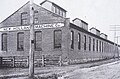 New Holland Machine Company, c. 1895
 -
 New Holland Borough sign in front of Garden Spot High School
 -
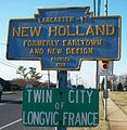 Keystone marker and Sister City sign on Route 23 near Garden Spot High School


Notable people[edit]
- John Wesley Davis, former Speaker of the United States House of Representatives
- Todd O'Brien, professional basketball player
- Brenda Stauffer, bronze medal recipient in the 1984 Summer Olympics
- Richard Winters, WWII officer and veteran of D-Day, Market Garden, Carentan and the Battle of the Bulge; main character in Band of Brothers
References[edit]
- ^ "ArcGIS REST Services Directory". United States Census Bureau. Retrieved October 12, 2022.
- ^ a b "Census Population API". United States Census Bureau. Retrieved Oct 12, 2022.
- ^ a b Bureau, US Census. "City and Town Population Totals: 2020-2021". Census.gov. US Census Bureau. Retrieved 9 July 2022.
- ^ "Total Population: 2010 Census DEC Summary File 1 (P1), New Holland borough, Pennsylvania". data.census.gov. U.S. Census Bureau. Retrieved September 9, 2020.
- ^ "The Ranks of the Ranks: A history of the Ranck (Ranc) Family in Lancaster County"
- ^ "A Brief History of New Holland". Retrieved 2009-01-07.
- ^ "National Register Information System". National Register of Historic Places. National Park Service. July 9, 2010.
- ^ "History". Archived from the original on 2007-12-31. Retrieved 2008-12-15.
- ^ "US Gazetteer files: 2010, 2000, and 1990". United States Census Bureau. 2011-02-12. Retrieved 2011-04-23.
- ^ "2019 U.S. Gazetteer Files". United States Census Bureau. Retrieved July 28, 2020.
- ^ "new_holland_secondary_doc.pdf" (PDF). model-railroad-hobbyist.com. Model Railroad Hobbyist Magazine. Retrieved 11 December 2016.
- ^ "Census of Population and Housing". U.S. Census Bureau. Retrieved 11 December 2013.
- ^ a b "U.S. Census website". United States Census Bureau. Retrieved 2008-01-31.
- ^ "Incorporated Places and Minor Civil Divisions Datasets: Subcounty Resident Population Estimates: April 1, 2010 to July 1, 2012". Population Estimates. U.S. Census Bureau. Archived from the original on 11 June 2013. Retrieved 11 December 2013.
- ^ "Elanco Library".
- ^ "New Holland Farmers Fair". Pcrdesigns.net. Archived from the original on 13 April 2014. Retrieved 12 April 2014.
- ^ "New Holland Farmers Fair".
- ^ "NEW HOLLAND FARMERS FAIR ANNOUNCES CHANGES FOR 2020" (PDF). 22 May 2020.
External links[edit]
- Official website
- A Brief History of New Holland
- New Holland Farmer's Fair
- New Holland Weather
- New Holland Historical Society

| International | |
|---|---|
| National | |