
Ripponlea railway station
Ripponlea | ||||||||||||||||||||||||||||||||||||||||||||||||||||||||||||||||||||||
|---|---|---|---|---|---|---|---|---|---|---|---|---|---|---|---|---|---|---|---|---|---|---|---|---|---|---|---|---|---|---|---|---|---|---|---|---|---|---|---|---|---|---|---|---|---|---|---|---|---|---|---|---|---|---|---|---|---|---|---|---|---|---|---|---|---|---|---|---|---|---|
| PTV commuter rail station | ||||||||||||||||||||||||||||||||||||||||||||||||||||||||||||||||||||||
 Northbound view, November 2021 | ||||||||||||||||||||||||||||||||||||||||||||||||||||||||||||||||||||||
| General information | ||||||||||||||||||||||||||||||||||||||||||||||||||||||||||||||||||||||
| Location | Glen Eira Road, Ripponlea, Victoria 3185 City of Port Phillip Australia | |||||||||||||||||||||||||||||||||||||||||||||||||||||||||||||||||||||
| Coordinates | 37°52′33″S 144°59′42″E / 37.8759°S 144.9951°E | |||||||||||||||||||||||||||||||||||||||||||||||||||||||||||||||||||||
| Owned by | VicTrack | |||||||||||||||||||||||||||||||||||||||||||||||||||||||||||||||||||||
| Operated by | Metro Trains | |||||||||||||||||||||||||||||||||||||||||||||||||||||||||||||||||||||
| Line(s) | Sandringham | |||||||||||||||||||||||||||||||||||||||||||||||||||||||||||||||||||||
| Distance | 9.83 kilometres from Southern Cross | |||||||||||||||||||||||||||||||||||||||||||||||||||||||||||||||||||||
| Platforms | 2 side | |||||||||||||||||||||||||||||||||||||||||||||||||||||||||||||||||||||
| Tracks | 2 | |||||||||||||||||||||||||||||||||||||||||||||||||||||||||||||||||||||
| Connections |
| |||||||||||||||||||||||||||||||||||||||||||||||||||||||||||||||||||||
| Construction | ||||||||||||||||||||||||||||||||||||||||||||||||||||||||||||||||||||||
| Structure type | Ground | |||||||||||||||||||||||||||||||||||||||||||||||||||||||||||||||||||||
| Bicycle facilities | Yes | |||||||||||||||||||||||||||||||||||||||||||||||||||||||||||||||||||||
| Accessible | Yes—step free access | |||||||||||||||||||||||||||||||||||||||||||||||||||||||||||||||||||||
| Other information | ||||||||||||||||||||||||||||||||||||||||||||||||||||||||||||||||||||||
| Status | Operational, host station | |||||||||||||||||||||||||||||||||||||||||||||||||||||||||||||||||||||
| Station code | RIP | |||||||||||||||||||||||||||||||||||||||||||||||||||||||||||||||||||||
| Fare zone | Myki Zone 1 | |||||||||||||||||||||||||||||||||||||||||||||||||||||||||||||||||||||
| Website | Public Transport Victoria | |||||||||||||||||||||||||||||||||||||||||||||||||||||||||||||||||||||
| History | ||||||||||||||||||||||||||||||||||||||||||||||||||||||||||||||||||||||
| Opened | 1 May 1912 | |||||||||||||||||||||||||||||||||||||||||||||||||||||||||||||||||||||
| Electrified | 1500 V DC overhead (May 1919) | |||||||||||||||||||||||||||||||||||||||||||||||||||||||||||||||||||||
| Passengers | ||||||||||||||||||||||||||||||||||||||||||||||||||||||||||||||||||||||
| 2005–2006 | 544,171[1] | |||||||||||||||||||||||||||||||||||||||||||||||||||||||||||||||||||||
| 2006–2007 | 582,849[1] | |||||||||||||||||||||||||||||||||||||||||||||||||||||||||||||||||||||
| 2007–2008 | 614,903[1] | |||||||||||||||||||||||||||||||||||||||||||||||||||||||||||||||||||||
| 2008–2009 | 675,480[2] | |||||||||||||||||||||||||||||||||||||||||||||||||||||||||||||||||||||
| 2009–2010 | 718,704[2] | |||||||||||||||||||||||||||||||||||||||||||||||||||||||||||||||||||||
| 2010–2011 | 708,724[2] | |||||||||||||||||||||||||||||||||||||||||||||||||||||||||||||||||||||
| 2011–2012 | 659,004[2] | |||||||||||||||||||||||||||||||||||||||||||||||||||||||||||||||||||||
| 2012–2013 | Not measured[2] | |||||||||||||||||||||||||||||||||||||||||||||||||||||||||||||||||||||
| 2013–2014 | 727,060[2] | |||||||||||||||||||||||||||||||||||||||||||||||||||||||||||||||||||||
| 2014–2015 | 714,429[1] | |||||||||||||||||||||||||||||||||||||||||||||||||||||||||||||||||||||
| 2015–2016 | 788,960[2] | |||||||||||||||||||||||||||||||||||||||||||||||||||||||||||||||||||||
| 2016–2017 | 748,125[2] | |||||||||||||||||||||||||||||||||||||||||||||||||||||||||||||||||||||
| 2017–2018 | 747,752[2] | |||||||||||||||||||||||||||||||||||||||||||||||||||||||||||||||||||||
| 2018–2019 | 656,564[2] | |||||||||||||||||||||||||||||||||||||||||||||||||||||||||||||||||||||
| 2019–2020 | 531,200[2] | |||||||||||||||||||||||||||||||||||||||||||||||||||||||||||||||||||||
| 2020–2021 | 244,200[2] | |||||||||||||||||||||||||||||||||||||||||||||||||||||||||||||||||||||
| 2021–2022 | 276,600[3] | |||||||||||||||||||||||||||||||||||||||||||||||||||||||||||||||||||||
| Services | ||||||||||||||||||||||||||||||||||||||||||||||||||||||||||||||||||||||
| ||||||||||||||||||||||||||||||||||||||||||||||||||||||||||||||||||||||
| ||||||||||||||||||||||||||||||||||||||||||||||||||||||||||||||||||||||
Ripponlea railway station is located on the Sandringham line in Victoria, Australia. It serves the south-eastern Melbourne suburb of Ripponlea, and opened on 1 May 1912.[4]
The station is located at the up (northern) end of the Glen Eira Road level crossing, with station access from Glen Eira Road, Oak Grove and Morres Street.
History[edit]
Opening on 1 May 1912, Ripponlea station, like the suburb itself, was named after the Rippon Lea Estate, which was formed by Frederick Thomas Sargood, businessman and a member of Parliament for the Victorian Legislative Council between 1874–1880 and 1882–1901, and a senator for Victoria between 1901 and 1903.[5][6]
In 1960, boom barriers replaced interlocked gates at the Glen Eira Road level crossing,[7] with the signal box protecting the level crossing also abolished during that time.[4]
Platforms and services[edit]
Ripponlea has two side platforms. Platform 1 has a large weatherboard building, with a smaller weatherboard building on Platform 2. There is a footbridge immediately south of the station buildings, which connects the two platforms, and allows pedestrians to cross the railway tracks.
It is served by Sandringham line trains.[8]
Platform 1:
- Sandringham line all stations services to Flinders Street
Platform 2:
- Sandringham line all stations services to Sandringham
Transport links[edit]
CDC Melbourne operates one bus route via Ripponlea station, under contract to Public Transport Victoria:
- 623 : Glen Waverley station – St Kilda[9]
Yarra Trams operates one route via Ripponlea station:
Gallery[edit]
-
 Northbound view from the Glen Eira Road level crossing, April 2005
 -
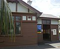 Station front and entrance to Platform 1, November 2021


References[edit]
- ^ a b c d Estimated Annual Patronage by Network Segment Financial Year 2005-2006 to 2018-19 Department of Transport
- ^ a b c d e f g h i j k l Railway station and tram stop patronage in Victoria for 2008-2021 Philip Mallis
- ^ Annual metropolitan train station patronage (station entries) Data Vic
- ^ a b "Ripponlea". vicsig.net. Retrieved 20 January 2023.
- ^ "Ripponlea". Victorian Places. Retrieved 20 January 2023.
- ^ First, Jamie (7 January 2014). "The A-Z story of Melbourne's suburbs". Herald Sun. Retrieved 20 January 2023.
- ^ John Sinnatt (January 1990). "Level Crossing Protection". Somersault. Signalling Record Society Victoria. pp. 9–17.
- ^ "Sandringham Line". Public Transport Victoria.
- ^ "623 Glen Waverley - St Kilda via Mount Waverley & Chadstone & Carnegie". Public Transport Victoria.
- ^ "67 Melbourne University - Carnegie". Public Transport Victoria.
External links[edit]
- Melway map at street-directory.com.au