
Niel, Belgium
Niel | |
|---|---|
 | |
 Flag Coat of arms | |
Location of Niel  | |
 Niel Location in Belgium
Location of Niel in the province of Antwerp  | |
| Coordinates: 51°07′N 04°20′E / 51.117°N 4.333°E | |
| Country | |
| Community | Flemish Community |
| Region | Flemish Region |
| Province | Antwerp |
| Arrondissement | Antwerp |
| Government | |
| • Mayor | Tom De Vries (Open VLD) |
| • Governing party/ies | N-VA, Open Vld |
| Area | |
| • Total | 5.35 km2 (2.07 sq mi) |
| Population (2020-01-01)[1] | |
| • Total | 10,546 |
| • Density | 2,000/km2 (5,100/sq mi) |
| Postal codes | 2845 |
| NIS code | 11030 |
| Area codes | 03 |
| Website | www.niel.be |
Niel (Dutch pronunciation: [nil] ⓘ) is a municipality located in the Belgian province of Antwerp. The municipality only comprises the town of Niel proper. In 2021, Niel had a total population of 10,493. The total area is 5.27 km2.[2]
History[edit]
Niel used to belong to the Lordship of Mechelen. In 1462, it became part of the Duchy of Brabant. Niel became an independent parish in the 14th century. During most of its history, it was an agricultural community along the Rupel river. In the 19th century, Niel became an industrial town with brickworks, cement factories and shoe factories.[3]
Sports[edit]
Niel is home to the Niel Jaarmarkt Cyclo-cross, a cyclo-cross race held in and around the town. The race forms part of the X²O Badkamers Trophy.
Notable people[edit]
- Jan Decleir, actor, leading actor in the Academy Award winner Karakter was born in Niel.
Gallery[edit]
-
 Town hall
 -
 House in Niel
 -
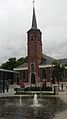 Our Lady Church in Niel
 -
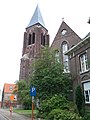 St Josef Church in Hellegat


References[edit]
- ^ "Bevolking per gemeente op 1 januari 2020". Statbel.
- ^ "Bevolking per statistische sector - Sector 12030D". Statistics Belgium. Retrieved 10 May 2022.
- ^ "Niel". Agentschap Onroerend Erfgoed (in Dutch). Retrieved 11 May 2022.
External links[edit]
 Media related to Niel, Belgium at Wikimedia Commons
- (in Dutch) Official website

| International | |
|---|---|
| National | |
| Geographic | |
This Antwerp Province location article is a stub. You can help Wikipedia by expanding it. |