
Querrien
Querrien
Kerien | |
|---|---|
 Querrien village hall | |
.svg) Coat of arms | |
Location of Querrien  | |
 Querrien  Querrien | |
| Coordinates: 47°57′38″N 3°32′08″W / 47.9606°N 3.5356°W | |
| Country | France |
| Region | Brittany |
| Department | Finistère |
| Arrondissement | Quimper |
| Canton | Quimperlé |
| Intercommunality | CA Quimperlé Communauté |
| Government | |
| • Mayor (2020–2026) | Stéphane Cado[1] |
| Area 1 | 54.01 km2 (20.85 sq mi) |
| Population (2021)[2] | 1,655 |
| • Density | 31/km2 (79/sq mi) |
| Time zone | UTC+01:00 (CET) |
| • Summer (DST) | UTC+02:00 (CEST) |
| INSEE/Postal code | 29230 /29310 |
| Elevation | 13–172 m (43–564 ft) |
| 1 French Land Register data, which excludes lakes, ponds, glaciers > 1 km2 (0.386 sq mi or 247 acres) and river estuaries. | |
Querrien (French pronunciation: [kɛʁjɛ̃]; Breton: Kerien) is a commune in the Finistère department of Brittany in northwestern France.
Population[edit]
Inhabitants of Querrien are called in French Querriennois.
|
| ||||||||||||||||||||||||||||||||||||||||||||||||||||||||||||||||||||||||||||||||||||||||||||||||||||||||||||||||||
| |||||||||||||||||||||||||||||||||||||||||||||||||||||||||||||||||||||||||||||||||||||||||||||||||||||||||||||||||||
| Source: EHESS[3] and INSEE (1968-2020)[4] | |||||||||||||||||||||||||||||||||||||||||||||||||||||||||||||||||||||||||||||||||||||||||||||||||||||||||||||||||||
Geography[edit]
The village centre is located 10 km (6.2 mi) north of Quimperlé.
Neighbouring communes[edit]
Querrien is border by Lanvénégen to north, by Meslan and Locunolé to east, by Tréméven and Mellac to south and by Saint-Thurien to west.
Map[edit]

Breton language[edit]
The municipality launched a linguistic plan concerning the Breton language through Ya d'ar brezhoneg on 7 March 2007.
Gallery[edit]
-
 Chapel of Notre Dame de la Clarté
 -
 Fountain of La Clarté
 -
 Manor of Kervagat
 -
 Celtic stele of Kervagat
 -
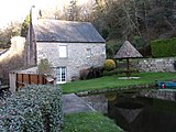 Mill of Kerivarch


.jpg)


See also[edit]
References[edit]
- ^ "Répertoire national des élus: les maires" (in French). data.gouv.fr, Plateforme ouverte des données publiques françaises. 13 September 2022.
- ^ "Populations légales 2021". The National Institute of Statistics and Economic Studies. 28 December 2023.
- ^ Des villages de Cassini aux communes d'aujourd'hui: Commune data sheet Querrien, EHESS (in French).
- ^ Population en historique depuis 1968, INSEE
- Mayors of Finistère Association (in French)
External links[edit]
Wikimedia Commons has media related to Querrien.
| International | |
|---|---|
| National | |
This Finistère geographical article is a stub. You can help Wikipedia by expanding it. |