
Coaticook
Coaticook | |
|---|---|
 Main Street | |
| Nickname: Pearl of the Eastern Townships[1] | |
 Location within Coaticook RCM. | |
 Coaticook Location in southern Quebec. | |
| Coordinates: 45°08′N 71°48′W / 45.133°N 71.800°W[2] | |
| Country | |
| Province | |
| Region | Estrie |
| RCM | Coaticook |
| Settled | 1820s |
| Incorporated | 1864 |
| Constituted | December 30, 1998 |
| Government | |
| • Mayor | Simon Madore |
| • Federal riding | Compton—Stanstead |
| • Prov. riding | Saint-François |
| Area | |
| • Total | 222.73 km2 (86.00 sq mi) |
| • Land | 219.51 km2 (84.75 sq mi) |
| Population (2021)[4] | |
| • Total | 8,867 |
| • Density | 40.4/km2 (105/sq mi) |
| • Pop 2016-2021 | |
| • Dwellings | 4,025 |
| Time zone | UTC−5 (EST) |
| • Summer (DST) | UTC−4 (EDT) |
| Postal code(s) | |
| Area code(s) | 819, 873, 468 |
| Highways | |
| Website | www |
Coaticook (English: /koʊˈætɪkʊk/; Quebec French pronunciation [kwatsɪkʊk]) is a town on the Coaticook River, located in southeastern Quebec, Canada. It resides in the region of Estrie, which is often referred to colloqually as the Eastern Townships.[5] It is the seat of the Coaticook Regional County Municipality, and its southern border is also the Canada–United States border.
The town of Coaticook was initially settled in the 1820s by British Loyalists coming from New England. The town was incorporated in 1864, and the municipalities of Barnston Township and Barford Township were later merged into Coaticook on December 12, 1998. The absorption of these townships introduced multiple communities to Coaticook that exist to this day, including Baldwin's Mills, Barnston, Ladd's Mills and Stanhope. As of 2021, the population of the municipality of Coaticook was 8,867 with a total area of 222.73 square kilometres (86.00 sq mi).
The town of Coaticook is principally known for the Laiterie de Coaticook, the Parc de la Gorge de Coaticook and Foresta Lumina, which bring in a majority of the town's tourists.
The municipality is named after the Coaticook River. The name “Coaticook” is of Abenaki origin, deriving from the term koatikeku, meaning “where the river is bordered by white pines”.[6]
History[edit]

The place was founded in 1818. Richard Baldwin Senior, from Barnston Pinacle cleared a parcel of land where later the City Hall was built. Richard Baldwin son, built the first permanent residence at this place. The area of the Townships of Barnston and Barford was settled in the 1820s and the 1830s by British Loyalists and Americans, mainly from New England.[7][8][9] The municipality was finally incorporated in 1864. After the merger of the municipalities of Barnston Township and Barford Township on December 12, 1998, the surface area of the newly-created municipality increased considerably.
Coaticook now extends over a total land area of 218.89 square kilometres and the 108 animal farms within its territory, including 66 dairy farms, make it one of Quebec's major milk producers.[10][11] Coaticook is dubbed the Pearl of the Eastern Townships.
Geography[edit]
Climate[edit]
| Climate data for Coaticook, Quebec | |||||||||||||
|---|---|---|---|---|---|---|---|---|---|---|---|---|---|
| Month | Jan | Feb | Mar | Apr | May | Jun | Jul | Aug | Sep | Oct | Nov | Dec | Year |
| Record high °C (°F) | 17.8 (64.0) |
17.0 (62.6) |
24.5 (76.1) |
29.5 (85.1) |
31.7 (89.1) |
33.3 (91.9) |
35.0 (95.0) |
34.4 (93.9) |
32.2 (90.0) |
28.9 (84.0) |
25.0 (77.0) |
17.8 (64.0) |
35.0 (95.0) |
| Mean daily maximum °C (°F) | −5.1 (22.8) |
−2.8 (27.0) |
2.4 (36.3) |
10.4 (50.7) |
17.6 (63.7) |
22.4 (72.3) |
24.6 (76.3) |
23.6 (74.5) |
19.1 (66.4) |
11.8 (53.2) |
5.0 (41.0) |
−1.9 (28.6) |
10.6 (51.1) |
| Daily mean °C (°F) | −9.8 (14.4) |
−7.9 (17.8) |
−2.5 (27.5) |
5.3 (41.5) |
12.0 (53.6) |
17.0 (62.6) |
19.4 (66.9) |
18.4 (65.1) |
14.1 (57.4) |
7.4 (45.3) |
1.3 (34.3) |
−6.0 (21.2) |
5.7 (42.3) |
| Mean daily minimum °C (°F) | −14.5 (5.9) |
−12.9 (8.8) |
−7.3 (18.9) |
0.2 (32.4) |
6.3 (43.3) |
11.6 (52.9) |
14.1 (57.4) |
13.2 (55.8) |
9.0 (48.2) |
2.9 (37.2) |
−2.5 (27.5) |
−10 (14) |
0.8 (33.4) |
| Record low °C (°F) | −41.7 (−43.1) |
−36.1 (−33.0) |
−29.4 (−20.9) |
−20.0 (−4.0) |
−7.8 (18.0) |
−2.2 (28.0) |
−1.1 (30.0) |
−1.1 (30.0) |
−5.6 (21.9) |
−10.6 (12.9) |
−25.0 (−13.0) |
−36.1 (−33.0) |
−41.7 (−43.1) |
| Average precipitation mm (inches) | 80.9 (3.19) |
69.8 (2.75) |
76.3 (3.00) |
81.2 (3.20) |
101.1 (3.98) |
124.7 (4.91) |
116.1 (4.57) |
128.9 (5.07) |
96.5 (3.80) |
104.8 (4.13) |
96.9 (3.81) |
98.8 (3.89) |
1,176 (46.30) |
| Average rainfall mm (inches) | 22.2 (0.87) |
18.0 (0.71) |
29.6 (1.17) |
67.9 (2.67) |
100.1 (3.94) |
124.7 (4.91) |
116.1 (4.57) |
128.9 (5.07) |
96.5 (3.80) |
100.2 (3.94) |
70.7 (2.78) |
33.6 (1.32) |
908.6 (35.77) |
| Average snowfall cm (inches) | 58.7 (23.1) |
51.9 (20.4) |
46.7 (18.4) |
14.1 (5.6) |
1.0 (0.4) |
0.0 (0.0) |
0.0 (0.0) |
0.0 (0.0) |
0.0 (0.0) |
4.6 (1.8) |
26.2 (10.3) |
65.2 (25.7) |
268.3 (105.6) |
| Source: Environment Canada[12] | |||||||||||||
Demographics[edit]
In the 2021 Census of Population conducted by Statistics Canada, Coaticook had a population of 8,867 living in 4,023 of its 4,282 total private dwellings, a change of -1% from its 2016 population of 8,955. With a land area of 219.45 km2 (84.73 sq mi), it had a population density of 40.4/km2 (104.6/sq mi) in 2021.[4]
| 2021 | 2016 | 2011 | |
|---|---|---|---|
| Population | 8,867 (-1.0% from 2016) | 8,698 (-6.0% from 2011) | 9,255 (+0.6% from 2006) |
| Land area | 219.45 km2 (84.73 sq mi) | 219.51 km2 (84.75 sq mi) | 218.57 km2 (84.39 sq mi) |
| Population density | 40.4/km2 (105/sq mi) | 39.6/km2 (103/sq mi) | 42.3/km2 (110/sq mi) |
| Median age | 48.0 (M: 46.0, F: 50.0) | 46.5 (M: 44.7, F: 48.0) | 44.1 (M: 42.9, F: 45.4) |
| Private dwellings | 4,282 (total) 4,023 (occupied) | 3,956 (total) | 4,208 (total) |
| Median household income | $62,000 | $50,677 | $43,230 |
Mother tongue:[19]
- English as first language: 5.1%
- French as first language: 92.7%
- English and French as first language: 1.3%
- Other as first language: 0.8%
Attractions[edit]
Laiterie de Coaticook[edit]
Founded in 1940 by Arthur Bédard, Arthur St-Cyr, and Henri Gérin, the Laiterie initially prepared, bottled, and distributed pasteurized dairy products such as milk, chocolate milk, and cream. Only two years later did the Laiterie begin the production of its quickly-famed ice cream and cheddar cheese. In 1976, under the new administration of Fernand Houle and Émile Provencher, the Laiterie chose to halt the distribution of milk, chocolate milk, and cream. These specializations permitted the Laiterie to position itself firmly on the market. Over the next 50 years, the Laiterie expanded its product range, adding new flavors of ice cream, goat cheese, "Bûche de Noël" cakes, and several other products. Today, still relying on one manufactory, its products are sold province-wide and in New Brunswick.[20]
Parc de la Gorge de Coaticook[edit]
First opened in 1975, the Parc de la Gorge de Coaticook is a regional park situated on the Coaticook Gorge. It is a nonprofit organization that offers both summer and winter activities, including camping, hiking trails, a petting zoo, mountain bike trails, and in winter, snowshoeing, fatbike, ice climbing and dog sledding.[21] The Parc de la Gorge de Coaticook brings in more than 225,000 visitors annually, with the principal attraction of the park being its suspension bridge which spans the gorge at 169 meters (554 ft) long. The footbridge dates back to 1988, however it was officially opened the year after, and initially held the title of longest suspended footbridge in the world according to Guinness World Records until 2006, when a footbridge in Japan surpassed it. The Park has two receptions in the town of Coaticook: the first being the Accueil Denis Maurais, renamed after the founder of the Parc de la Gorge de Coaticook in 2016,[22] which gives access to the suspension bridge and Foresta Lumina, and the second being the Accueil du Camping, located in a round barn, which gives access to the park's campgrounds as well as the majority of its trails and other activities. Both receptions also act as shops, selling merchandise and memorabilia connected to the four main activities of the park.[23]
Foresta Lumina was created in 2014, when the Parc de la Gorge de Coaticook commissioned Moment Factory, a Montreal-based design studio, to create a multimedia night walk in one of the park's trails. The 2.6 km (1.6 mi) long experience drew inspiration from local legends, making use of different scenography techniques, a unique soundtrack and a story revolving around a girl named "Margaret".[24] Its first year saw over 70,000 visitors, and in 2015, it received over 145,000. In each of the consecutive years after 2014, large changes or additions were made to Foresta Lumina. In 2018, a projection was added to the downtown of Coaticook, located in Tillotson Place, which is accessible by the main street.[25][26]
The Parc Découverte Nature is an affiliated organism owned and managed by the Parc de la Gorge de Coaticook. It is located in Baldwin Mills, near Lake Lyster, and offers activities that revolve around fishing. It was first created in 2004, when the municipality of Coaticook obtained 80 hectares of land next to the pisciculture center located in Baldwin Mills. The land was transferred to the Parc de la Gorge de Coaticook and it started year-round activities in May 2006. Today, the Parc Découverte Nature sees more than 11,000 visitors annually and is involved in the conservation of multiple local species of freshwater fish.[27] In August 2019, in collaboration with local and government agencies, it was announced that the Parc Découverte Nature would open an interactive game experience by the summer of 2020.[28] Due to the Covid-19 pandemic, the opening was pushed until July 2021, when it was revealed as Acoatica, an interactive experience with the goal of favoring the survival of different fish species through different interior and exterior activities.[29]
Sports[edit]
Coaticook is home to the Coaticook Big Bill of the Ligue de Baseball Senior Élite du Québec, which play their home games in Julien Morin Stadium.
Infrastructure[edit]
Cemeteries[edit]
Cemeteries in or near Coaticook include Mount Forest Cemetery,[30] Saint Edmond Cemetery,[31][32] St-Luc and St-Wilfrid-de-Barnston.
Gallery[edit]
-
 Child street in 2014.
 -
 The historic Eastern Townships Bank, now a branch of CIBC.
 -
 The town's old post office, now the town's library (Bibliothèque Françoise-Maurice de Coaticook).
 -
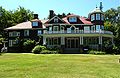 The Beaulne house, now home to the town's museum.
 -
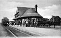 The old Coaticook station, located on the Grand Trunk railway.
 -
 The town's hospital in 1954.


See also[edit]
References[edit]
- ^ "Portrait de la Ville". Ville de Coaticook. Ville de Coaticook. Retrieved 2 August 2023.
- ^ "Banque de noms de lieux du Québec: Reference number 351657". toponymie.gouv.qc.ca (in French). Commission de toponymie du Québec.
- ^ a b "Coaticook - Répertoire des municipalités". Ministère des Affaires municipales et de l'Habitation. Ministère des Affaires municipales et de l'Habitation. Retrieved 2 August 2023.
- ^ a b c "Population and dwelling counts: Canada, provinces and territories, and census subdivisions (municipalities), Quebec". Statistics Canada. February 9, 2022. Retrieved August 29, 2022.
- ^ Grant, Josh. "Quebec's Eastern Townships considers official name change". CBC News. CBC. Retrieved 2 August 2023.
- ^ A Look at Origins and Geography, virtualmuseum.ca
- ^ Historical highlights of the region, tourismecoaticook.ca
- ^ Heritage in motion, magazinecontinuite.com
- ^ Great Pioneer Builders, virtualmuseum.ca
- ^ Coaticook Bridging town and country, circuitsdecouvertecoaticook.org
- ^ Coaticook, baladodecouverte.com
- ^ "Coaticook, Quebec Climate". Canadian Climate Normals 1981–2010 (in English and French). Environment Canada. 31 October 2011. Retrieved July 16, 2015.
- ^ a b "Electronic Area Profiles". Canada 1996 Census. Statistics Canada. Retrieved 2014-01-28.
- ^ "2021 Community Profiles". 2021 Canadian Census. Statistics Canada. February 4, 2022. Retrieved 2023-10-19.
- ^ "2016 Community Profiles". 2016 Canadian Census. Statistics Canada. August 12, 2021. Retrieved 2017-11-29.
- ^ "2011 Community Profiles". 2011 Canadian Census. Statistics Canada. March 21, 2019. Retrieved 2014-01-28.
- ^ "2006 Community Profiles". 2006 Canadian Census. Statistics Canada. August 20, 2019.
- ^ "2001 Community Profiles". 2001 Canadian Census. Statistics Canada. July 18, 2021.
- ^ "Coaticook community profile". 2021 Census data. Statistics Canada. 29 March 2023. Retrieved 2023-08-04.
- ^ À propos de nous, laiteriedecoaticook.com/
- ^ "Winter activities". Parc de la Gorge de Coaticook. Retrieved 3 August 2023.
- ^ Cliche, Vincent. "Bienvenue au Pavillon Denis-Maurais". Le progrès de Coaticook. Retrieved 3 August 2023.
- ^ Sage, Caroline. "Parc de la gorge de Coaticook". Société d'histoire de Coaticook. Retrieved 3 August 2023.
- ^ "History". Foresta Lumina. Retrieved 3 August 2023.
- ^ "Foresta Lumina". Moment Factory. Retrieved 3 August 2023.
- ^ Studio, Capitales. "Le Parc de la Gorge de Coaticook : magnifique de jour comme de soir". La Tribune. Retrieved 3 August 2023.
- ^ "About us". Parc Découverte Nature. Retrieved 3 August 2023.
- ^ McClure, Taylor. "Parc Découverte Nature unveils new $2.7 million interactive game". Sherbrooke Record. Retrieved 3 August 2023.
- ^ Petit, Josée. "L'AVENTURE D'ACOATICA AU PARC DÉCOUVERTE NATURE EST OFFICIELLEMENT LANCÉE!". Parc de la Gorge de Coaticook. Retrieved 3 August 2023.
- ^ "Mount Forest Cemetery, Coaticook, Stanstead County, Quebec". interment.net. Retrieved 2009-11-08.
- ^ "Liste des cimetières du diocèse". Cimetière Saint-Michel-de-Sherbrooke (in French). Archived from the original on 2011-07-25. Retrieved 2009-11-08.
- ^ "Saint Edmond Cemetery, Coaticook, Stanstead County, Quebec". interment.net. Retrieved 2009-11-08.
External links[edit]
- (in French) Ville de Coaticook
Adjacent Municipal Subdivisions | |
|---|---|
| Cities | |
|---|---|
| Municipalities | |
| Townships | |
| Communities | |
| |
| International | |
|---|---|
| National | |
| Other | |